


2018 School Spending Survey Report
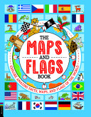
The Maps and Flags Book: Explore Amazing Facts, Maps, and Flags of the World
COPY ISBN
VERDICT Easy to absorb information presented in readable prose and bright drawings make this volume a welcome addition to collections. Selectors should consider.
ALREADY A SUBSCRIBER? LOG IN
We are currently offering this content for free. Sign up now to activate your personal profile, where you can save articles for future viewing
ALREADY A SUBSCRIBER? LOG IN
Thank you for visiting.
We’ve noticed you are using a private browser. To continue, please log in or create an account.

Be the first reader to comment.
Comment Policy:
Comment should not be empty !!!