


2018 School Spending Survey Report
Maps, Globes, and a Few Lessons in Geography | Touch and Go
Join us for a look at some recent geography releases for early elementary to middle school students. The apps offer different approaches to the topic; together they cover both physical and human geography.
Interior screen from 'The Barefoot Atlas' (Touch Pr./Barefoot Bks.)
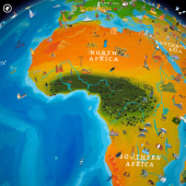
Join us for a look at some recent geography releases for early elementary to middle school students. The apps represent productions from developers well-known to educators: Touch Press/Barefoot Books; Kids Discover; and Oceanhouse Media. The three groups offer different approaches to the topic; together they cover both physical and human geography. The Barefoot World Atlas delighted users when it was launched in 2012, and they now have a reason to return to app. Five extension packs (Touch Press/Barefoot Books/Royal Geographic Society; S1.99 ea.; K-Gr 5), are available, offered individually as in-app purchases.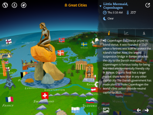
Screen from 'Great Cities' (Touch Pr./Barefoot Bks)
“Great Cities” and “North America” are excellent supplements to the information found in the original app. Colorful, illustrated icons correspond with 100 cities across the globe in the first extension pack, and the states and provinces in the US and Canada in the second. The Little Mermaid sculpture represents Copenhagen, skyscrapers signify Tokyo, and Boston is home to Fenway Park. The soothing background music changes to reflect the different geographic regions as users swipe the screen to spin the globe. Tapping on an icon will open a live feed of information that includes the time, weather, and population of a particular location. Children have the option of reading the information provided about each city, or listening to it as it is read aloud. The “Puzzles” geography games are organized by region and continent and will provide children with hours of fun. The objective for each is the same; tap and drag the shape of the state, province, or nation to the correct location on its corresponding country or continent map. At times, the angle of the globe, coupled with the scrolling menu of shapes at the bottom of the screen, makes viewing a bit difficult, but users may zoom in and out to change the angle and improve the view. For children who enjoy a bit of competition, there’s a timer and score card at the top of the screen. Upon completing a puzzle, users can email their score or post it to Twitter or Facebook.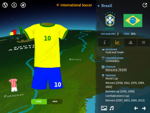
Screen from 'International Soccer' (Touch Pr./Barefoot Bks.)
Consider the “International Soccer” extension a must purchase for soccer fans as the 2014 World Cup approaches. Tapping on uniform icons will reveal information about each of the 209 soccer (football) teams represented. A few facts about the history of the each team is included as well as their current FIFA ranking, trophies won, a photo of the home stadium, scores of recent games and upcoming matches, and the manager’s and team member's names. Pictures of both home and away uniforms are provided. A click on the music icon starts the country’s national anthem.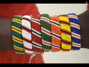
Bracelets worn by the Maasai from 'World Art' (Touch Pr./Barefoot Bks.)
The “World Art” pack is by far the most impressive addition. One hundred items have been “carefully selected” to show “how different cultures have created and viewed art, from prehistory to the present day.” Readers will learn about each object’s artist, dimensions, medium, and its current location. Background information on the piece is offered, providing additional context. Users may also open a full- screen photo of the selection for an up-close look. Throughout, the text poses questions, engaging children as it encourages them to consider an artist’s choices. For example, viewers are asked the following about Picasso’s “Guernica”: “Why do you think the painting is in black, gray and white, rather than in color?” “If you were an artist and wanted to tell the world something important, what sort of art would you choose to communicate your message?” Additionally, for each image a sliding tile puzzle is available. Children will spend endless hours with these entertaining—and educational—additions to the Barefoot World Atlas. A trailer is available for the "Puzzle" pack. According to the developer’s website, more extension packs are in the works.–Cathy Potter, Falmouth Elementary School, Falmouth, ME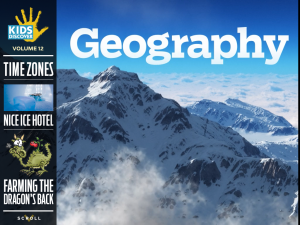 With its mixture of engaging text, color photos, animations, cartoons, videos, and mini-assessments, Geography (Kids Discover/Joe Zeff Design, $3.99; Gr 3-7) by Marjorie Franl makes an excellent nonfiction addition to collections. The opening chapter distinguishes between physical geography and the work of human geographers, and the app delves a bit into both. The quality the 3D graphics will enhance children’s understanding of the concepts presented. In one animation, an orange with a world map drawn on it is unpeeled to introduce different types of map projections. Clearly illustrated discussions of longitude and latitude, time zones, and other related topics follow. Later chapters consider natural phenomena such as the migration of peoples over millennium and the more recent past, and homes around the world from the Cliff Palace in Mesa Verde National Park in Colorado to a cottage in Wales.
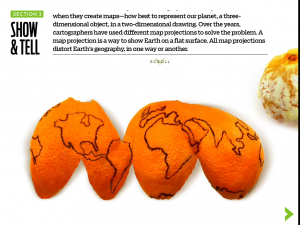
Screen from 'Geography' (Kids Discover)
Readers can slide an object to reveal more detailed text and clicking on a question mark reveals answers. Interactive elements are available on most pages. Short embedded film clips help explain concepts such as land use and adaptation, while chapters on rivers and the changing Earth offer visuals of Niagara Falls and flowing lava. Making excellent use of the iPad’s gyroscope, the app offers panoramic views of the Hoover Dam and the Grand Canyon. Readers can also simulate the motion of an earthquake by shaking the device at one screen. Audio is added to some pages. The “Activities” section prompts readers to answer simple questions and is followed by a “Resources” page, which contains links to websites for further information. Links to other geography sources lead readers to Amazon. The high-quality text and breathtaking photography make this app an excellent tool to teach physical and human geography.--Sydnye Cohen, Technology Integrator, New Canaan High School, New Canaan, CT
Screen from 'There's a Map in My Lap!" (Oceanhouse Media) Ruiz
In Tish Rabe's There’s a Map On My Lap! (Oceanhouse Media $5,99; Gr 2-5),The Cat in the Hat takes viewers for a ride in his thing-a-ma-jigger using a map to guide the way. A well-paced rhyming text and vibrant illustrations by Aristides Ruiz, animated in this edition, introduce young readers to globes, atlases, plans, and marine charts, and topographical, street, and subway maps, among others. The text also offers explanations about their key components including legends and longitude and latitude lines. Information is presented in layers, providing greater detail for children with some background knowledge on the topic. Sidekicks Thing 1 and Thing 2 provide easy-to-understand meanings for such terms as “scale” (shrinks “miles into inches on each map” and “makes everything smaller….”). However, tapping on the word reveals a more formal definition. Throughout, readers can touch images to see the written word for the item and hear it pronounced, a useful feature when introducing terms such as “compass rose” and “cartographer.” Navigation is straightforward and features such as sound effects can be disabled. Children can choose to listen to the lively narration or to personalize the story by recording their own voices. This app presents elementary students with a thorough look at the types of maps. Overall, a great teaching tool and vocabulary builder; with its money-back guarantee, teachers can’t lose.–Deirdre Reddington, Uniondale High School Library Uniondale, NY For additional app reviews, visit the Touch and Go webpage.
Added To Cart
RELATED


RECOMMENDED
CAREERS
The job outlook in 2030: Librarians will be in demand
CAREERS
The job outlook in 2030: Librarians will be in demand
ALREADY A SUBSCRIBER? LOG IN
We are currently offering this content for free. Sign up now to activate your personal profile, where you can save articles for future viewing
ALREADY A SUBSCRIBER? LOG IN
Thank you for visiting.
We’ve noticed you are using a private browser. To continue, please log in or create an account.
Add Comment :-
Be the first reader to comment.
Comment Policy:
Comment should not be empty !!!